


The Hawaii topography is a tale of fiery origins and serene beauty. The landscape has been shaped by volcanic might and caressed by ocean waves, resulting in one of the most unique, picturesque places in the world.
But what is the topography of Hawaii, exactly? And how exactly did it come to be?
We’ll unfold the layers of Hawaii's geological story, revealing how each island's unique contours and features came to be. You’ll discover the vibrant interplay between land, climate, and ecology as we delve into the island-by-island breakdown of the geology of Hawaii.
You can browse our Hawaii topographic map art collection to get a better appreciation of the state’s terrain in stunning detail when it’s all said and done, too!
What is the Topography of Hawaii?
First things first…what is the topography of Hawaii? We’re going to look at the Hawaii topography across the various islands in detail, but we need to explain what topography means before going any further.
Defining Topography
Topography refers to the arrangement of the natural and artificial physical features of an area. In the context of Hawaii, it encompasses everything from towering volcanic peaks and lush valleys to rugged coastlines and intricate river systems.
The topography of Hawaii is a direct reflection of its geology, a dynamic landscape shaped over millions of years by volcanic activity, erosion, and the relentless forces of the ocean. So, what is the topography of Hawaii?
Island-by-Island Hawaii Topography Breakdown
Each island in Hawaii showcases its unique geologic identity, shaped by its age, volcanic history, and erosional processes. Here’s an island-by-island Hawaii topography breakdown:
- Hawaii Island (The Big Island): The Big Island is home to Mauna Kea and Mauna Loa, two of the world’s largest volcanoes. It’s a living laboratory of volcanic Hawaii geology. Its topography features recent lava flows, volcanic craters, and lush rainforests, showcasing the ongoing process of island-building.
- Maui: Maui's topography is marked by the massive dormant Haleakalā volcano crater and the West Maui Mountains. Erosion has sculpted deep valleys and ridges, creating a diverse landscape of desert-like areas and verdant regions.
- Oahu: Oahu's geology features two mountain ranges - the Waianae and Koolau - separated by a central plain. The island's topography includes the iconic Diamond Head, a volcanic tuff cone, and the dramatic cliffs of the Nuuanu Pali Lookout.
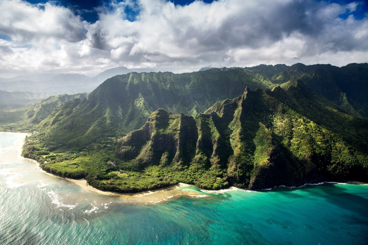
- Kauai: This is the oldest of the main Hawaiian Islands. Kauai's geology reveals deep erosional patterns. The island is renowned for the Waimea Canyon, often described as the “Grand Canyon of the Pacific”, and the spectacular cliffs of the Napali Coast.
- Molokai, Lanai, and Niihau: These islands may not be the first you think of when envisioning the topography of Hawaii, but they have distinct topographical features worth noting. Molokai boasts the world’s tallest sea cliffs, Lanai offers a unique lunar-like landscape at the Garden of the Gods, and Niihau's arid environment results in a more subdued topography.
The geology of Hawaii's islands is a story of how the forces of nature shape our world. The topography of Hawaii reveals the powerful and ongoing process of island creation and evolution with its vast array of landscapes. Let’s take a deeper look at how this all came to be.
The Birth of an Archipelago: How the Geology of Hawaii Came to Be

The Hawaiian Islands owe their existence to a remarkable geological phenomenon. The story of their birth and evolution is a testament to the powerful forces at work beneath the Earth's surface.
Volcanic Origins
At the heart of Hawaii's formation lies the concept of a hotspot, a plume of molten rock that wells up from deep within the Earth's mantle.
This hotspot has remained stationary over millions of years while the Pacific Plate (a massive tectonic plate upon which the Pacific Ocean rests) slowly moves over it. The hotspot feeds the creation of volcanoes as the plate moves, which emerge above the ocean's surface, giving birth to the islands.
The geology of Hawaii is marked by this volcanic activity. The islands are essentially the visible tips of a vast underwater mountain range, formed by countless eruptions over millions of years.
The Hawaiian hotspot is currently under the Big Island, where volcanic activity continues to shape the land. This can be seen in the ever-changing landscapes of Kilauea and Mauna Loa.
Island Evolution
The forces of erosion start shaping an island’s topography as soon as it emerges from the ocean. The islands evolve over time, transitioning from young, volcanic landscapes to older, deeply eroded terrains. The age of each island plays a crucial role in its current topography.
For instance, the Big Island is the youngest. It’s characterized by its rugged, volcanic terrain with minimal erosion. In contrast, Kauai is the oldest in the main archipelago and exhibits extensive erosional features, including deep canyons and sculpted mountain ridges.
The gradual process of erosion, combined with the islands' volcanic origins, creates the diverse and dynamic landscapes that we see today. And this topography matters more than you may realize - it’s not just for looks…
The Impact of Hawaii Topography on Climate and Ecology
Hawaii's topography plays a pivotal role in shaping the islands' diverse climates and rich ecological tapestry. The dramatic variations in elevation, combined with the islands' geographical position, create a unique environmental mosaic.
Climate Zones Across the Islands
Hawaii is renowned for its multitude of climate zones, ranging from tropical rainforests to arid deserts, all compressed into a relatively small geographical area. This climatic diversity is largely due to the islands' varied topography.
The towering heights of volcanoes like Mauna Kea and Mauna Loa create rain shadows, leading to dry conditions on their leeward sides, while their windward sides receive abundant rainfall.
This results in distinct microclimates within short distances. You can experience stark temperature and humidity shifts just by traversing Maui's Haleakalā Crater, for example.
Biodiversity and Natural Habitats
The islands' topographical diversity is a crucible for ecological richness. Each habitat, from coastal beaches to misty mountaintops, supports unique ecosystems. The lush, windward slopes of the islands are home to dense rainforests, while the drier leeward areas feature more sparse vegetation.
This varied landscape provides a haven for an array of endemic species, which have evolved to thrive in these specific conditions. Hawaii's isolation has also led to a high degree of endemism, making it a biodiversity hotspot.
Human Influence on the Hawaiian Landscape
From the ancient Polynesians to modern developments, human activities have altered the natural topography and ecosystems.
Agricultural practices, urbanization, and the introduction of invasive species have been particularly transformative. These changes have led to challenges in preserving Hawaii's unique ecological balance and natural beauty.
Conservation of Hawaii's Topographical Wonders

The preservation of Hawaii's diverse topographical wonders is not just an environmental imperative but a cultural and historical one. After all, these islands are irreplaceable treasures with their unique volcanic formations, lush valleys, and vibrant ecosystems.
Conservation efforts in Hawaii focus on protecting these landscapes from the threats of urbanization, invasive species, and climate change.
Key initiatives include habitat restoration projects, which aim to revive native flora and fauna and curb the spread of invasive species that threaten the islands' ecological balance.
Programs like watershed protection are crucial in maintaining the health of Hawaii's water systems, which are essential for sustaining the islands' diverse habitats.
Another significant aspect of conservation is cultural preservation. Many of Hawaii's landscapes are deeply intertwined with Native Hawaiian culture and traditions. Protecting these areas helps preserve the rich heritage and history of the Hawaiian people.
Governmental and non-governmental organizations alike, collaborate in these efforts, understanding that the conservation of Hawaii's topography is vital for future generations.
Through education and sustainable tourism, they also strive to foster a deeper appreciation and respect for these natural wonders among residents and visitors alike.
Understanding Hawaii Geology and Topography Through Maps
One of the best ways to appreciate Hawaii geology and topography is through maps. We’ll introduce you to our topographic and relief maps of Hawaii shortly - but here’s why maps are such a powerful way to understand the topography and geology of Hawaii.
The Art and Science of Topographical Mapping
Topographical maps are a fusion of art and science, offering a detailed three-dimensional representation of a region's surface. They bring to life the islands' volcanic origins, rugged terrains, and varied elevations.
They use contour lines to illustrate the shape and elevation of the land, allowing viewers to visualize the rise and fall of the terrain, from the soaring peaks of volcanoes to the deep canyons carved by centuries of erosion.
These maps also detail human-made features like roads and trails, providing a comprehensive view of how the natural and human worlds intersect.
Elevations of Hawaii: Highs and Lows
Hawaii's topography is marked by its dramatic elevation changes. The Big Island, for instance, boasts Mauna Kea, rising to 13,796 feet above sea level, while Maui's Haleakalā reaches 10,023 feet.
These elevations contribute to the islands' diverse climates and ecosystems. Topographical maps of Hawaii highlight these elevations, offering insight into the geological forces at play and how they influence everything from weather patterns to biodiversity.
The Role of Water: Rivers, Waterfalls, and Coastal Influences
Water shapes Hawaii's landscape in profound ways. Rivers, originating from high mountain peaks, carve out valleys and gorges as they travel to the ocean.
Hidden gems within lush rainforests like waterfalls reveal the island's volcanic underpinnings and erosional forces. The interaction between land and ocean along the coasts creates unique features like sandy beaches, rugged cliffs, and coral reefs.
Topographical maps trace these waterways and coastal lines, illustrating how water is a constant, shaping force in the Hawaiian landscape. And you can analyze these unique features up close and personal at Muir Way!
Get a Whole New Appreciation for the Topography and Geology of Hawaii at Muir Way!
Discover Hawaii as you’ve never seen it before with Muir Way’s map collection. Our prints are a journey into the heart of Hawaii's geological splendor, blending art with the science of cartography.
The detailed craftsmanship and museum-quality materials make these prints a valuable addition to any space, be it your home or office. With so many different maps to choose from, you’re sure to find something that captivates you. Here are 5 of our favorites:
- Hawaii Elevation Map: This map intricately details the volcanic activities that birthed this island paradise. You can trace the majestic rise of the Mauna Loa and Mauna Kea and explore the rugged terrains formed by centuries of lava flows and erosions. Each elevation shift is captured with precision, inviting you to appreciate the natural forces that molded these islands.
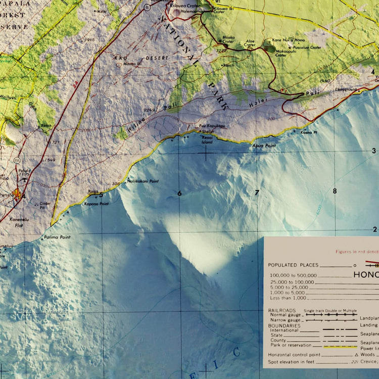
- Big Island’ 1975 Hawaii Relief Map: This vintage map highlights the island’s complex volcanic structure as it was understood nearly half a century ago. It's a fascinating look at the evolving understanding of Hawaii’s geology, offering a historical perspective on the Big Island’s majestic landscape.
- Hawaii Hydrological Map: Every curving river and stream tells a story of water shaping the land. From the powerful cascades of Akaka Falls to the serene flows along the Wailuku River, this map is a tribute to the life-giving force of water in the Hawaiian landscape.
- Haleakala National Park Map: Remember or dream of your Hawaiian adventures with this keepsake of the breathtaking landscapes of Maui. The map's detailed contours and elevations bring the park’s stunning terrain to life, from the summit of Haleakala to the verdant Kīpahulu District.
- Hawaiian Islands 1971 Shaded Relief Map: Experience Hawaii's topography like never before with the Hawaiian Islands 1971 Shaded Relief Map from Muir Way. This map artfully combines Digital Elevation Data and sonar-imaged bathymetry to create a stunning illusion of depth, capturing the islands' terrain and ocean floor in exquisite detail.
And while you came here to discover the geology of Hawaii, we have a myriad of other state maps worth exploring such as our Texas topographic map, Tennessee topographic map, and Colorado topographic map.
You can also check out specific collections like our Civil War battle maps, maps of mountains in the US, high-quality national park map posters, vintage maps, USA national park maps and more.
Wrapping Up Our Hawaii Topography Guide
We hope this exploration of the topography and geology of Hawaii has left you with a deeper appreciation for the islands' dynamic landscapes and geological wonders. From the soaring volcanic peaks to the serpentine rivers carving through lush valleys, Hawaii's natural beauty is both profound and captivating.
We have more articles to help you experience the wonders of the world such as our guide to the American mountain ranges, Appalachian trail planning guide, Rocky Mountain National Park guide, and California National Parks guide.
Otherwise, continue your journey into the heart of Hawaii’s topography at Muir Way with our museum-quality wall art. Each map is a fusion of art, history, and science, offering a unique perspective on the Hawaiian islands.
Discover these visual treasures and enrich your appreciation of the topography of this majestic terrain today!
