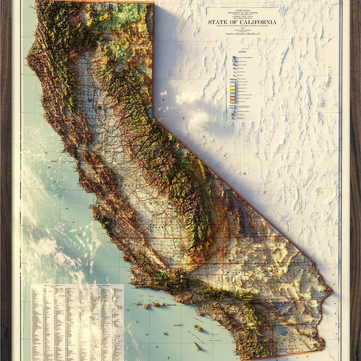


Factory Seconds - California Regional Hydrological Map 24x30 Inch
Currently 10 people are looking at this product
Paper Print - Factory Seconds
These prints have minor imperfections but are otherwise beautiful and printed to last. We are offering these at a deep discount. Inventory is very limited and will not be replenished.
Defects may include:
-Minor scuffs or creasing around the edges of the print
-Slight discolorations or tiny ink spots
-Printed at a size we do not normally carry
-Border widths that were not cut correctly
Description
Our series of regional hydrological maps show the Water Resource Regions of the USA which is the first level of classification used by the USGS. Its purpose is to divide the US into smaller hydrologic units which are then subdivided. The 21 major Water Resource Regions contain the drainage area of either a major river or the combined drainage areas of a series of rivers.

Water is literally the lifeblood of our country. If you’re drawn to water, you know that how and where it flows tells the story of a place. The California Water Resource Region contains the drainages into the Pacific Ocean from within California as well as the drainages from the Great Basin that discharge into California. This map shows in fascinating detail how the rivers and streams flow and interconnect, merge and diverge, carrying life to the land. The flow of water also has an inherent aesthetic elegance that our map captures beautifully.
It’s all in the details. Our map depicts every river in the Water Resource Region—even intermittent streams—and every body of water with a diameter greater than .2 miles. For an extra aesthetic touch, we apply a method called the Strahler Stream Order to show the hierarchy of streams as they flow from their source—rivers are shown thicker as they acquire the flow of tributaries. We think it enhances a sense of the interconnectedness of our waterways.
In our Hydrology Series, you’ll not only find your favorite rivers and lakes, but you’ll also be able to trace their origins and outflow and appreciate the beauty of their connections.
Shipping and Returns
FREE SHIPPING on orders to the contiguous US over $49 with UPS ground or USPS to PO Boxes.
Unframed prints - Printed to order and shipped within 2-3 business days
Framed prints - Custom framed and will ship in 3-4 weeks
Full refund on returns of unframed paper prints within 30 days of purchase. Prints must be returned in NEW condition without creases or damage. Please email us at info@muir-way.com for instructions.
If prints are shipped back to us and are not in new condition, we offer a store credit or can return them to you.
We do NOT ACCEPT returns or exchanges on framed prints or canvas wraps because they are made to order.
Click HERE for more information on shipping and returns.
Gallery Quality
Made in the USA
We consider our maps to be works of art, so we print and frame them accordingly.
Using award-winning printers with gallery quality fine art paper and inks, our maps will exceed expectations and last a lifetime.
- Archival Paper and Inks
- 100% Cotton, OBA-Free, and Acid-Free
- Heavyweight 21.5 mil
- Certified to last 100 years
Read customer reviews HERE attesting to the quality of our prints.