


Europe's geology is a captivating narrative of transformation and diversity, sculpted by ancient origins, tectonic shifts, and the ebb and flow of ice ages.
This rich geological history has shaped a continent of striking contrasts, from the majestic Alps to the serene Scandinavian fjords. In exploring this terrain, we catch glimpses of the planet's deep past and the dynamic processes that continue to mold its surface.
Our maps here at Muir Way offer a unique perspective on these timeless landscapes, allowing you to hang them up on your wall to appreciate Mother Nature's artistry. We’ll introduce you to our Europe relief map collection below as we unpack the geology of Europe in detail!
The Geological Formation of Europe
Let’s go all the way back to the beginning to take a look at how Europe’s geology came to be.
The Ancient Origins From Gondwana to Laurasia
The story of Europe’s geology begins about 600 million years ago during the Precambrian and early Paleozoic eras. The landmasses that now makeup Europe were part of Gondwana, located in the Southern Hemisphere.
As the eons passed, continental drift and plate tectonics began reshaping the Earth's surface. By the late Paleozoic era, around 300 million years ago, the European continental fragments started their northward migration towards the equatorial Laurasia, leading to the formation of the supercontinent Pangaea.
This colossal geological shift laid down the foundations for modern Europe, with many of today’s mountain ranges originating from the collision and amalgamation of these ancient landmasses. The same is true of US mountain ranges as well, which are unique in their own right.
Tectonic Movements That Shaped the European Continent
The Alpine orogeny, which began in the late Mesozoic era and continued into the Cenozoic era, is a prime example of how the geology of Europe was largely a result of tectonic plate interactions.
This was triggered by the collision of the African and Eurasian plates, giving rise to the Alps, a process that continues to this day as these plates still converge. The formation of the Pyrenees, Carpathians, and the Apennines followed similar patterns.
Europe's plains and basins, like the Great European Plain and the Pannonian Basin, were also formed due to these tectonic movements, as subsidence created space for sediment to accumulate over millions of years.
Ice Ages and Their Impact on Europe's Terrain
The Pleistocene glaciations which began around 2.6 million years ago have had a profound impact on Europe's landscape. These glacial periods saw large parts of the continent, especially in the north, covered by thick ice sheets.
These glaciers were powerful agents of change, eroding mountains, carving out valleys and fjords, and depositing vast amounts of sediment.
Retreating glaciers left behind a rugged landscape dotted with lakes and fjords in Scandinavia, a hallmark of glacial erosion.
The British Isles were sculpted in similar fashion, with features like the U-shaped valleys of the Lake District and the rolling hills of the Scottish Highlands bearing testament to the erosive power of ice.
The glacial cycles also played a crucial role in shaping the river systems of Europe, with many rivers like the Danube and the Rhine following paths carved out by retreating glaciers.
Distinct Geological Regions of Europe

From the ancient bedrock of the Scandinavian Shield to the dynamic formation of the Alps, the tranquil expanse of the Central European Plains, and the complex structures of the Mediterranean Basin, there are a few regions in particular that showcase the continent's rich geological tapestry.
The Scandinavian Shield
The Scandinavian Shield is one of Europe's oldest geological formations with its bedrock dating back over 2.5 billion years. This ancient craton is primarily found in Sweden, Finland, and parts of Norway and Russia.
It’s characterized by its hard, Precambrian metamorphic and igneous rocks. These rocks are the remnants of ancient mountain ranges (which are now eroded), exposing some of the oldest rock formations on Earth.
The shield played a significant role during the Ice Ages, with its surface being heavily reshaped by glacial activity. This process left behind a landscape filled with distinctive features such as smoothed bedrock surfaces, elongated lakes, and numerous boulders deposited by retreating glaciers.
We have an awesome Scandinavia 1922 shaded relief map that depicts some of these features in great detail.
The Formation of the Alps
The Alps are undoubtedly Europe's most famous mountain range. That being said, they are a relatively young formation, dating back to the Tertiary period, around 65 to 5 million years ago.
The immense pressure from the collision of the African and Eurasian tectonic plates folded, faulted, and uplifted the Earth's crust, creating the high peaks and deep valleys characteristic of the Alps.
This region is a prime example of Alpine orogeny, a process of mountain building that also created many of Europe's other major ranges. See it in a whole new way with our Alps 1965 shaded relief map!
The Central European Plains
The Central European Plains stretch from France to Russia and stand testament to the continent's more recent geological past.
Formed primarily during the Cenozoic era, these plains are characterized by their relatively flat and low-lying terrain. The shaping of this landscape was influenced by several factors, including sediment deposition from rivers, the retreat of glaciers from the last Ice Age, and subsidence due to tectonic activity.
This region is crucial for Europe’s agriculture, providing fertile soil and a mild climate conducive to crop growth.
The Mediterranean Basin
The Mediterranean Basin is a unique geological region formed by the complex interplay of tectonic plate movements, sea level changes, and sedimentary processes.
This area is bordered by mountain ranges like the Alps and the Atlas, and includes the Mediterranean Sea, a result of the closure of the ancient Tethys Ocean.
The basin has been significantly shaped by the African plate moving towards the Eurasian plate, leading to the formation of numerous islands, deep sea basins, and active volcanoes like Vesuvius and Etna.
This region is not only geologically diverse but also rich in biodiversity and cultural history, reflecting its dynamic geological evolution.
Iconic Geological Landmarks of Europe

Europe's geological diversity is not just evident in its varied landscapes but also in its iconic landmarks, each telling a unique story of Earth's history. Let’s narrow our focus and look at some of the most fascinating natural wonders across the geology of Europe.
The White Cliffs of Dover
The White Cliffs of Dover are a striking natural feature located on the southern coast of England. Composed of chalk accented with streaks of black flint, these cliffs rise up to 350 feet above the English Channel.
Formed from the skeletal remains of microorganisms over millions of years, the cliffs date back to the Cretaceous period. They stand not only as a symbol of natural beauty but also as a historical and cultural icon, having played a significant role in British maritime history.
Norway’s Fjords
Norway's fjords are among the most dramatic and well-known features of Scandinavian geology. Carved by glacial activity during the Ice Ages, these deep, narrow inlets are flanked by towering cliffs and mountains.
The fjords were formed when glaciers retreated, allowing the sea to flood the U-shaped valleys. The result is a breathtaking landscape that includes some of the deepest and longest fjords in the world, such as Sognefjord and Hardangerfjord, showcasing the power and artistry of ice-age glaciation.
Iceland’s Volcanic and Geothermal Wonders
Iceland is a hotbed of volcanic and geothermal activity. This island nation offers a unique window into the inner workings of our planet, with its numerous active volcanoes, geysers, hot springs, and lava fields.
The interaction between the Eurasian and North American tectonic plates has created a dynamic landscape, with features like the dramatic Þingvellir Rift Valley and the famous Geysir, from which the word “geyser” originates.
We have an Iceland 1901 shaded relief map that depicts the mountains regions, derived from Digital Elevation Data and brought to life by meticulously adding shaded relief to the landscape.
The Giant's Causeway
Located in Northern Ireland, the Giant's Causeway is a unique geological formation known for its tens of thousands of basalt columns.
Formed approximately 60 million years ago due to volcanic activity, these interlocking columns, mostly hexagonal in shape, create a pavement-like structure leading into the sea.
This UNESCO World Heritage Site is a perfect example of volcanic basalt cooling and fracturing, resulting in a striking natural pattern.
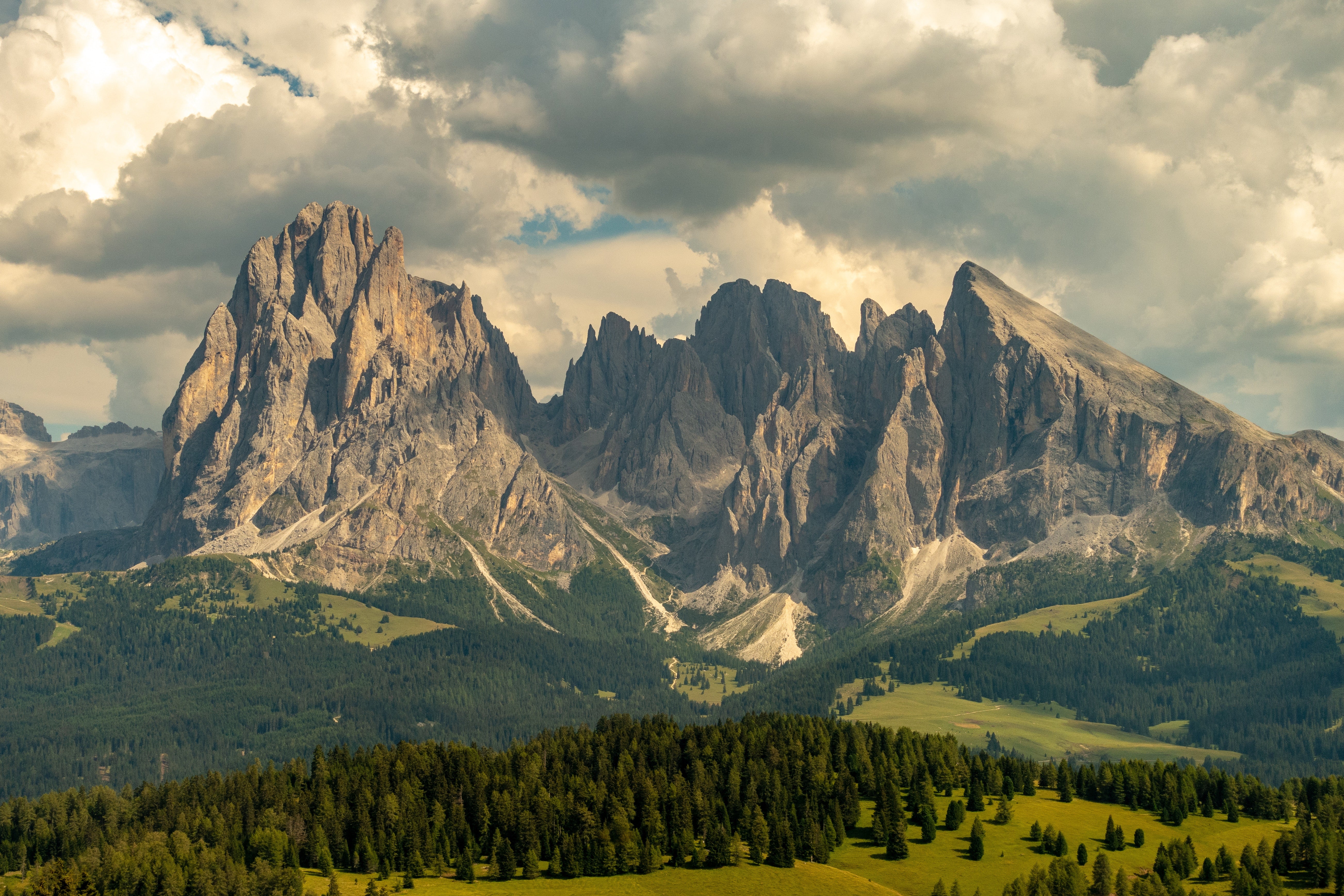
The Dolomites
The Dolomites, a spectacular mountain range in northeastern Italy, are celebrated for their stunning geological features.
Formed mainly from coral and marine sediment, these mountains showcase dramatic peaks, deep valleys, and soaring spires, creating a landscape of unparalleled beauty. They are a testament to the powerful forces of nature that have shaped them over millions of years.
Muir Way’s 1904 Shaded Relief Map of the Dolomites brings this breathtaking terrain to life with detailed 3D effects, highlighting the unique topography in a way that is both artistic and informative.
Karst Landscapes
Europe's karst landscapes are found in regions like the Dinaric Alps and parts of the Mediterranean. These are fascinating areas where water has eroded soluble rocks like limestone, dolomite, and gypsum.
This process has created unique topographies characterized by sinkholes, underground rivers, and spectacular cave systems.
The Škocjan Caves in Slovenia and the Burren in Ireland are prime examples of karst topography, offering insights into the slow yet persistent power of water in shaping the Earth’s surface.
Geological Hazards in Europe

There is no denying the beauty of Europe’s geology. However, the same forces that brought this beauty to life can be destructive in the form of earthquakes, volcanic eruptions, flooding, and landslides. We’ll look at a few examples of these happening in the geology of Europe below.
Earthquakes in the Mediterranean and Beyond
The Mediterranean region is particularly prone to seismic activity due to the complex interactions of the African and Eurasian tectonic plates.
For instance, Greece frequently experiences earthquakes. A recent example was a strong earthquake that hit the island of Evia, causing tremors that were felt in Athens. Though Greece often encounters such seismic events, they usually do not result in serious damage.
This indicates the regular occurrence of earthquakes in the region, reflecting the active tectonic nature of the Mediterranean basin.
This relief map of Greece and the Aegen Sea offers a unique perspective on this landscape, showcasing the mountains created from these tectonic movements over the course of time.
Volcanic Eruptions: Vesuvius, Etna, and Others
Europe is home to active volcanoes. Take Italy for example with Mount Vesuvius and Mount Etna being prominent examples. These volcanoes are part of the complex tectonic setting of the Mediterranean, where the African plate is subducting beneath the Eurasian plate.
In just the past few weeks Mount Etna has issued a stark reminder that it’s alive and well, spewing ash and soot high into the Italian skies while lava runs down its snowy slopes.
While significant eruptions have been a part of their history, modern monitoring systems help in predicting and mitigating the risks associated with volcanic activity.
Landslides and Flooding: Managing Risks
Landslides and flooding are other geological hazards that Europe faces. These events are often triggered by a combination of factors like heavy rainfall, unstable soil, and steep terrain.
In August 2023, Slovenia experienced devastating floods that led to significant property damage and evacuations. The prime minister of Slovenia estimated the damage at several billion euros, highlighting the substantial impact of such natural disasters.
Unfortunately, this is just one of many examples of flooding and landslides taking a toll on human life and economies.
But as we said from the beginning, these forces that are capable of causing such devastation are also the reason Europe’s geology is what it is. And, if you really want to appreciate the geology of Europe in a unique way, you can browse our Europe geology map collection at Muir Way!
Exploring Europe Through Geological Maps
Muir Way has an array of geological maps to help you appreciate the geology of Europe up close and personal, proudly displayed on your wall.
What are geological maps, exactly? They offer insights into the formation of its terrain, revealing the story behind each mountain fold and river valley. From showcasing the effects of ancient tectonic movements to illustrating the impacts of the Ice Ages, these maps are a visual narrative of geological history.

These museum-quality maps are a testament to the harmonious blend of art and science. They’re created with top-quality archival inks on 100% cotton, acid-free archival paper to ensure longevity and museum-quality presentation.
You can choose from authentic hardwood frames, handmade from walnut for an element of elegance and durability. Or, opt for the frameless canvas options for a modern, sleek look. Either way, the end result is a true work of art that expands your appreciation for Europe’s geology.
They vividly detail landforms, such as mountain ranges, valleys, and river systems, offering an educational and engaging way to understand the continent's diverse terrain and its formation over time.
While our Europe geology maps are an excellent addition to any home or office, we have an array of other worth exploring as well. That includes civil war battle maps, maps of US mountain ranges, 1883 US maps, national parks map posters, vintage maps, and more.
But, one of our most exciting is the 1962 Carte Tectonique Internationale De L'Eutope Geological map. This map is available with bathymetry - where the te added terrain under sea level was created with data derived from Sonar imaging.
Take a look and see what catches your eye as we wrap up this guide to the geology of Europe!
Final Thoughts on the Geology of Europe
Europe's geology is a story of ancient origins, dynamic tectonic movements, and transformative Ice Ages, shaping a continent rich in diverse landscapes and geological features.
From the ancient cratons of the Scandinavian Shield to the dramatic formation of the Alps, and from the sprawling Central European Plains to the intricate Mediterranean Basin, Europe's terrain reveals the complex and ever-evolving nature of our planet.
You can learn more about the world’s wonders in our blog. We have an Appalachian Trail guide, California National Parks guide, tips on visiting Rocky Mountain National Park, an overview of Hawaii geology, cartography, and more.
Otherwise, discover the geological wonders of Europe in detail with Muir Way's meticulously crafted maps today. Find out firsthand why we’ve earned more than 4,000 5-star reviews and counting!


