


American Civil War battle maps are where history is etched in ink and parchment. The battle maps of the Civil War are storytellers of a nation's most defining moments, allowing you to relive a bygone era to get a sense of what our ancestors experienced.
From the tactical genius of battlefield commanders to the strategic maneuvers that shaped a nation's destiny, each Civil War battle ground map is a window into the past. And you can discover the intricacies of topography, the art of map notations, and the thrill of collecting pieces of history here at Muir Way!
We’ll introduce you to our Civil War battle map collection and showcase some of the most pivotal moments from our country’s infamous internal feud. You’ll learn how to read these maps and how to display them proudly as a piece of art history on your own wall!
First, what is a United States Civil War battle map?
What Are American Civil War Battle Maps?
The American Civil War was a pivotal moment in the nation's history that saw not only the clashing of armies but also of strategies, landscapes, and wills. American Civil War battle maps serve as guides to these complex confrontations.
These maps are historical documents that offer a detailed glimpse into the tactics, terrains, and tumultuous events of the war. Let’s unravel the different types and talk about the process behind these works of art.
Types of Maps: Tactical, Strategic, and Topographic
There are three primary types of maps from the Civil War era worth noting:
- Tactical Maps: These were used for planning specific battles. They show detailed features of the battlefield such as troop positions, fortifications, and roads.
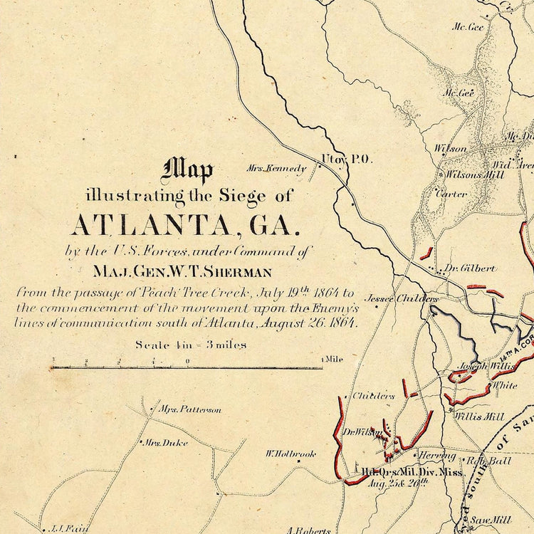
- Strategic Maps: These provided an overview of broader military campaigns and focused on larger-scale operations. They illustrate routes, supply lines, and key strategic points.
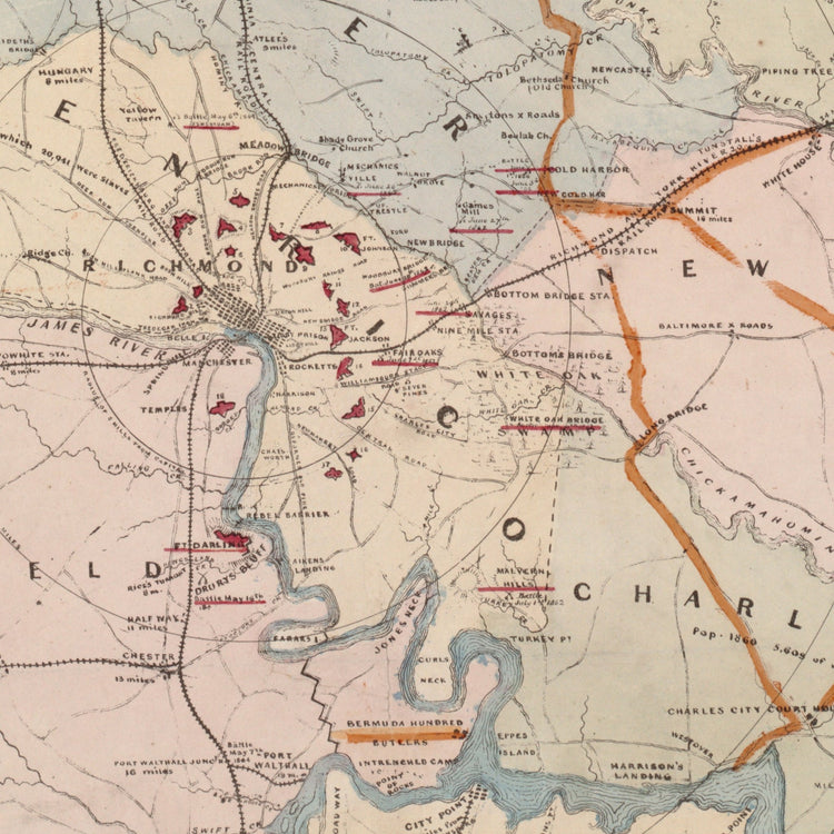
- Topographic Maps: These are essential for understanding the physical terrain of certain battle sites. They detail the natural landscape including hills, rivers, and valleys, all of which are crucial for planning military movements.
A Look Behind the Making of Civil War Battle Ground Maps
Crafting these maps required skill and an in-depth understanding of cartography. Cartographers often had to work in challenging and rapidly changing conditions.
They accompanied military soldiers and often found themselves right in the thick of the war. They had to quickly survey landscapes, using tools like compasses, clinometers, and anemometers. Their sketches and notes were then turned into detailed maps.
The Civil War era also witnessed significant advances in surveying and mapmaking, though. The use of theodolites for accurate measurements and lithography for printing allowed for the production of more detailed and accurate maps than ever before.
Notable Battle Maps of the Civil War
While each of the different battle maps of the Civil War tells an important story, some stand out for their historical significance and the insights they provide into the battles they represent. These include:
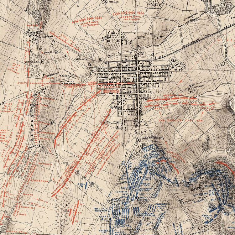
- Gettysburg: Perhaps the most famous American Civil War battle map. The maps of Gettysburg are detailed representations of the battlefield’s complex terrain, showcasing key locations like Little Round Top and Cemetery Hill.
- Antietam: This was the bloodiest single-day battle in American history. The maps of the Battle of Antietam highlight significant locations such as the Cornfield and Burnside’s Bridge, helping to understand the flow and phases of the battle.
- Bull Run: The First Battle of Bull Run maps provide insights into the first major battle of the war. They illustrate how the inexperienced armies maneuvered and engaged on the battlefield, setting the tone for the conflict's early stages.
What You’ll Learn in Deciphering a Civil War Battle Sites Map
Each American Civil War battle ground map serves as a guide not only to the geography of the battle but also to the strategies and decisions that shaped these pivotal events in American history. Here are the insights you can gather from analyzing a battle map of the Civil War…
Interpreting Terrain and Geography
Civil War battle site maps illustrate the strategic importance of terrain. Hills, rivers, and valleys were crucial factors in military tactics.
For instance, understanding why a particular hill was fiercely contested or how a river provided a defensive advantage can offer profound insights into the battle's outcome.
Understanding Symbols and Map Notations
Deciphering the symbols and notations is key to understanding a battle map of the Civil War. Symbols may indicate troop positions, artillery placements, and fortifications.
Lines and arrows can show troop movements and planned strategies. You can start to see the battlefield through the eyes of its commanders by learning to interpret these symbols.
Insights Into Military Strategy and Movement
Civil War battle site maps allow you to trace the movements of armies. They reveal the tactics used in famous battles. You get to see firsthand how terrain was utilized, where attacks were launched, and where defenses were established, almost as if you were there yourself.
Understanding these movements helps grasp the broader strategies employed by Union and Confederate leaders, and the often razor-thin margins between victory and defeat.
Why Battle Maps of the Civil War Are So Sought After
If you’re here reading about the battle maps of the Civil War, you probably already understand the deep appreciation for these maps. But if not, you may be wondering…what’s the point? The allure of Civil War battle maps extends far beyond their function as historical documents.
Historical Significance and Educational Value
Civil War battle maps are poignant reminders of a defining chapter in American history. They offer a tangible connection to the past, allowing us to visualize the complexities and scale of the conflict.
These maps serve as invaluable tools for teaching history as well. They provide a spatial context to the events, helping students and history buffs alike to grasp the strategic maneuvers and pivotal moments of the war.
The Thrill of Collecting Maps
United States Civil War battle maps are prized items for collectors, too. There is an entire community around these maps. And it’s easy to see why!
The thrill of collecting these Civil War battle site maps lies in the pursuit of rare finds, the discovery of unique details, and the pride of preserving a part of history.
The diversity of maps, from detailed tactical diagrams to sweeping strategic overviews, offers something for every type of collector, whether a novice or a seasoned enthusiast.
Unique Art Pieces
Battle maps of the Civil War transcend traditional historical artifacts, emerging as unique art pieces that blend historical intrigue with aesthetic appeal. Each map transforms into a captivating wall art piece with its intricate detail and rich storytelling.
They not only serve as striking visual focal points but also evoke deep reflection and conversation. They’re perfect for those who appreciate both the artistry of cartography and the profound narratives of history.
And, we’ve got just the thing if you want to experience the historical wonder of these Civil War battle site maps firsthand…
Want to Experience the Historical Wonder of a United States Civil War Battle Map Yourself?
There’s no denying the wonder of United States Civil War battle maps. But, how can you appreciate a battle map of the Civil War to the fullest? Let’s talk about what to look for and where you can shop with confidence.
What to Look For in a Piece of Map Wall Art
The key to selecting a piece of map wall art lies in finding a balance between aesthetic appeal and historical resonance. Look for maps that not only catch the eye but also tell a story. The richness of color, the clarity of territorial lines, and the detail of geographical features are crucial.
Accuracy is paramount for Civil War battle ground maps. These maps should reflect the historical events and locations they represent.
Pay attention to the quality of the paper and printing techniques. Archival-grade paper and fade-resistant inks ensure longevity and vibrancy.
Finally, consider the map's framing and mounting options, as these can greatly enhance the overall presentation and protect the map over time.
Why Shop at Muir Way?
We have a vast selection of the quality Civil War battle site maps you’re looking for here at Muir Way!
Every map is a work of art, combining historical significance with unparalleled craftsmanship. They’re designed to last for generations with museum-quality, 100% cotton, acid-free archival paper with fade-resistant inks.
The option of a handmade walnut frame adds an extra layer of elegance, ensuring your piece of history is preserved and presented with the utmost care. And, we have maps walking you through all the most prominent battles and the war as a whole. Here are some of our most popular:
- 1861-1865 Civil War Centennial Map: This map is a comprehensive chronicle of the entire Civil War period, outlining shifting battlefronts and territorial changes ove the 4 year span. You can trace the progression of major battles, troop movements, and pivotal moments that defined this era.
- A House Divided Map: This map vividly illustrates the states' allegiances (Union, Confederate, and Border States) and the ideological divide amongst them that led to conflict. It provides a stark visual representation of a nation split in two, highlighting key areas and dates where major conflicts erupted, and the ever-changing political landscape of the time
- Antietam Battlefield Map: This map showcases troop positions, movements, and strategic points on the battlefield. The viewer can follow the course of the battle, understanding the tactics and turning points that made Antietam a significant event in the Civil War.
- Battlefield of Gettysburg Map: This map captures the three-day Battle of Gettysburg, serving as a guide to one of the most pivotal moments of the Civil War. It lays out the positions and movements of Union and Confederate forces, key locations like Little Round Top and Cemetery Hill. You can appreciate how these maneuvers shaped the outcome of the battle and, ultimately, the war.
- Bull Run and Manassas Map: This map portrays the First and Second Battles of Bull Run (Manassas), highlighting the war’s initial confrontations. It shows troop alignments, the terrain challenges, and the battle's ebb and flow. Viewers can gain insight into how these early battles set the tone for the war and understand the tactical decisions made by both sides.
And beyond our Civil War battle site maps, you can explore our other vintage maps such as our US map in 1883. Other popular collections include US maps with mountains like the Appalachian mountain range map or Cascade mountain range map to celebrate the most significant mountain ranges in the US.
Or, check out our national parks map collection that helps you get an appreciation when visiting Rocky Mountain National Park, California National Parks, or hiking the Appalachian trail. Here are some tips on displaying your map no matter which you go with.
Tips on Displaying Your Map
Displaying your map in a way that enhances its beauty and historical significance is an art in itself. First, consider the lighting.
Natural light can bring out the colors and details of the map, but avoid direct sunlight to prevent fading. Artificial lighting, such as spotlights or gallery lights, can also accentuate different aspects of the map.
The location is equally important. Choose a spot where the map can be a focal point, such as above a fireplace, in a home office, or in a study.
Ensure the map is at eye level when you hang it for easy viewing and appreciation. If you have a collection of maps, consider creating a themed gallery wall that tells a story through the maps' progression.
Lastly, choose a frame that complements both the map and the room's decor. A well-chosen frame not only protects the map but also adds to its overall impact as a piece of art. We offer either black or walnut frames handmade from authentic hardwood. Or, go frameless!
Bringing Our American Civil War Battle Maps Guide to a Close
As we close this journey through the intricate world of American Civil War battle maps, we're reminded of the power these maps hold in connecting us to our past. They are storytellers, educators, and art pieces rolled into one.
Whether you're delving into the strategic intricacies of Bull Run, tracing the tumultuous events of Antietam, or exploring the iconic landscapes of Gettysburg, each map offers a unique window into history.
We celebrate this legacy at Muir Way by offering meticulously crafted maps that resonate with both history buffs and art lovers alike. Take a look today and see what catches your eye!


